St John Simpson, senior curator and archaeologist in the Department of the Middle East at the British Museum, offers a report from Winter excavations in southern Iraq
Kobeba? It is hardly a well-known name in the archaeological literature but is a site which has already produced important discoveries and featured twice on Iraqi state TV. In October 2021 I took a small team to southern Iraq, and returned there in November this year. Kobeba is actually a small cluster of mounds, not far from the town of al-Rifa’i in Dhi Qar governorate, midway between Baghdad and Basra.
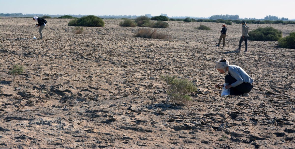
Systematic surface survey along transects on Kobeba 1
This is a region filled with sites of all periods, many badly affected by looting in 2003, but still only partly surveyed. There are many teams working in Iraq, including this region, but almost all of these are concerned with the beginnings of urban civilisation and focus on the city sites of the Sumerian and early Babylonian periods. The problem is that these are the exception: the landscape is filled with small and medium-sized sites, these are the ones most at risk from development, and we know almost nothing about them. This applies even more to the so-called ‘late periods’ of the Achaemenid, Seleucid, Parthian and Sasanian periods, and very little attention has been paid to any sites of the Islamic period here either.
Beginning open area excavations on Kobeba 1
The work at Kobeba is starting to address this imbalance and has produced some wonderful discoveries. It was first occupied at the beginning of the third millennium BC, a key transitional moment at the inception of urbanism and writing. This is known as the Jemdet Nasr period but much remains to be understood about it. During this period Kobeba was producing pottery, and among the debris in the potters’ quarter were purpose-made tools for scraping the insides of jars before they fired, the base of a solid-footed goblet with the accidental impression of the cord used to cut it off the hump as it was thrown on a wheel, and the remains of another which had been discarded before firing. The lower part of a gypsum vessel carved in low relief shows part of a reclining animal and belongs to a style of carved stone vessels typical of this period but hitherto known exclusively from the city-sites of Ur and Uruk to the south. The fragment of a pottery jar carefully incised after firing carries part of a pictographic inscription, preceding the later development of cuneiform. These two finds prove that literacy and the minor arts were not confined to the urban elites even at this early date.
Ceramic ring scraper and the scraping marks on the interior of a pottery jarPottery from the Jemdet Nasr periodPotsherd with part of a pictographic inscription of the Jemdet Nasr period
Kobeba was occupied and abandoned at intervals through the millennia which followed, a much more typical and dynamic pattern of settlement than the continuous occupation of the cities. A fragment of a polished calcite vessel found on the survey attests an import from eastern Iran: found in large numbers in the ‘Royal Cemetery’ at Ur, such luxuries have not been recognised at small sites, and it gives another hint of the unintentional bias affecting our understanding of the circulation of such goods.
The site was finally occupied in the Sasanian and early Islamic periods. The excavations have produced one of the few sequences from these periods, with a large assemblage of stratified pottery which already challenges the traditional dating of some of the most recognisable types used as ‘type fossils’ on archaeological surveys. Glazed wasters indicate that pottery continued to be made here during the Sasanian period. There is also a large amount of glass from the latest period, mostly open bowls and small plain bottles. This occupation dates to the eighth century and it was then that a small mudbrick mosque was built in an open area between rows of houses connected by narrow alleys and passages. The mosque was simple, unadorned, with a mihrab and a single door, and housing no more than 22 worshippers at once. This is a rare chance to see Islam in the local community, far from the big congregational mosques of the cities like Kufa or Wasit, yet an equally tangible expression of the need to build a dedicated place of prayer.
Trench 8: tannur and other features contemporary with a post-Sasanian structure (left) with the latest early Islamic level being excavated at the top
During this latest period, Kobeba continued its role as a centre of production, doubtless supplying smaller villages in the surrounding countryside. However, the core activity now was not pottery but grinding stones made by firing blocks of clay at up to 1200 degrees C, and then chipping and flaking away the corners and tops into the required circular shape, leaving great chunks of useless debitage discarded close by. This industry has a long history in Iraq, beginning at least by the early second millennium BC, when this so-called ‘synthetic basalt’ served as a hard-wearing local substitute for imported stone. Producing these must have required huge amounts of fuel, doubtless bushes or reeds gathered from all around, and also great care and skill to work the blanks into their final form. Fragments of such grinding stones are found at all of the Sasanian and early Islamic sites that I have visited in this region, but their production limited to a smaller number of places like Kobeba.
But why was Kobeba finally abandoned? Complete objects, including a copper alloy ladle, seals, coins and a cosmetic mortar, were found lying on the floors, suggesting that this may have been quite a rapid process. The result of civil war? Or disease? Either is historically possible, but there is a third possibility that also chimes with the present, namely lack of water. In hot regions such as southern Iraq, permanent occupation is completely reliant on the availability of fresh water for agriculture as well as drinking and washing. There is a massive water crisis in Iraq today as its upstream neighbours divert rivers into dams and irrigation schemes of their own, once fertile areas are abandoned, and processes of desertification are already underway in marginal areas.
Copper alloy dipper ladle in situRe-enactment of men at prayer in the excavated mosque
The forthcoming analyses of the plant and zooarchaeological remains will undoubtedly shed light on the food economy of Kobeba. The survival of pollen in core samples also offers a possibility for creating a detailed environmental reconstruction for the site. This is particularly exciting as geoarchaeological sections dug near the site show big changes in the soil sequences, with palaeo-marsh deposits contemporary with the latest period at Kobeba being replaced by dry clay. The effects of climate change are all around us today but it looks as if Kobeba may have suffered from environmental changes even earlier.
There is much to be done on the analysis of the results from Kobeba, but they offer new insights into everyday life in a Mesopotamian market town from the beginning of writing to the transition from Late Antiquity to the early medieval period.
Excavations and recording in progress of a refuse layer in ancient marshes surrounding the site; the low mound of Kobeba is in the background
A conference on the Rise of Parthia taking place in April 2020
The Parthian empire is by far the least understood of the great empires of antiquity. Until recently our knowledge has been both hazy and Euro-centric. In recent decades, however, new approaches have been adopted and these, together with new archaeological discoveries, are changing our preconceptions. Recognising this, in April 2020 the British Musuem will host leading international scholars presenting their most recent research on the history, culture and archaeology of the early Parthian Empire. Set against the complex political scenario of Iran, Mesopotamia and Asia Minor in the 2nd-1st centuries BC, speakers will address a wide range of issues on the rise of the empire and the relationship of the early Arsacids with their neighbours. Contributions will include re-evaluations of historical sources, analyses of material datasets, numismatics and reports on new work in the field. Specific themes addressed will include diplomacy, religion, sculpture, painting, chronology, ideological motifs, warfare and trade. This will lead to the promulgation of new models and a new understanding of the social, economic and political systems leading to the emergence of the Empire.
The conference will run in conjunction with two British Museum exhibitions – Rivalling Rome: Parthian coins and culture (April – September 2020) in the Museum itself; and the touring exhibition Ancient Iraq: New Discoveries, travelling to Nottingham and Newcastle (March-November 2020).
For details about the conference, including how to register, please visit the page on the British Museum website:
Malcolm Levitt suggests a generic multi-causal and dynamic framework to explain the collapse of ancient states
Dysfunctionality
Ancient states collapsed because they could not fulfil their core functions. This was because they failed to meet the conditions necessary to perform those functions. All this raises the questions of what those functions and necessary conditions were, and why they failed to meet them. Some readers might infer uncomfortable parallels with today’s societies or states but that theme is beyond the scope of this blog.
There is a considerable literature on the collapse of particular ancient states, much of it emphasising the role of a specific explanation for collapse. But mono-causal explanations are rarely sufficient and where multi-causal explanations are offered it is essential to analyse their dynamic interactions but relatively few studies do this. The aim here is to attempt a generic multi causal and dynamic framework to explain collapse.
We need to emphasise the importance of distinguishing between states and societies, a matter often bypassed by those who question the existence of collapse. States are institutionalised, centralised government structures whereas societies are the context of social structure, culture and common values in which states are moored. States can collapse as political entities while elements of their culture and values continue. To deny the collapse of the Western Roman Empire because elements of Roman culture thrived in Byzantium misses the point: states are political entities.
Ancient states were rooted in agriculture, sedentism and population growth. No state emerged without the presence of farming but farming is not a sufficient explanation of state formation: Mesopotamian crop management and animal husbandry long predated states. But grain especially was key to state formation, being taxable and useful paying soldiers and workmen. Growing population, enabled by improved diets, female energy and fertility, was the catalyst for state formation: meeting the demands for rising food production and distribution was beyond the management capacity of chieftains: assurance of food supplies was the founding core function of the bureaucratic state.
Nonetheless two routes to statehood were possible: consensus and egalitarianism or coercion and inequality; the latter tended to dominate or to supplant the former. They were fragile and prone to collapse.
Collapse
Sometimes explanations of collapse are seen as competing alternatives (such as intra-elite rivalry, invasion, popular uprisings) whereas they are not mutually exclusive in reality. Explanations of collapse in terms of competing mono-causal factors are inferior to those incorporating dynamic, interactive systems. In particular simultaneity is often ignored: where a factor is both determined by another and helps to determine the latter. Invasion might be induced by perceived military weakness in the invaded state but such weakness might be explained by loss of territory and part of the tax base to invaders and a vicious circle of fiscal depletion and dismemberment sets in. Natural catastrophe like drought, causing famine and popular unrest, might be exacerbated by neglect and mismanagement of key water infrastructures such as irrigation, flood control and grain and water storage. Diagram A illustrates such a model.
Diagram A. Collapse Explanations
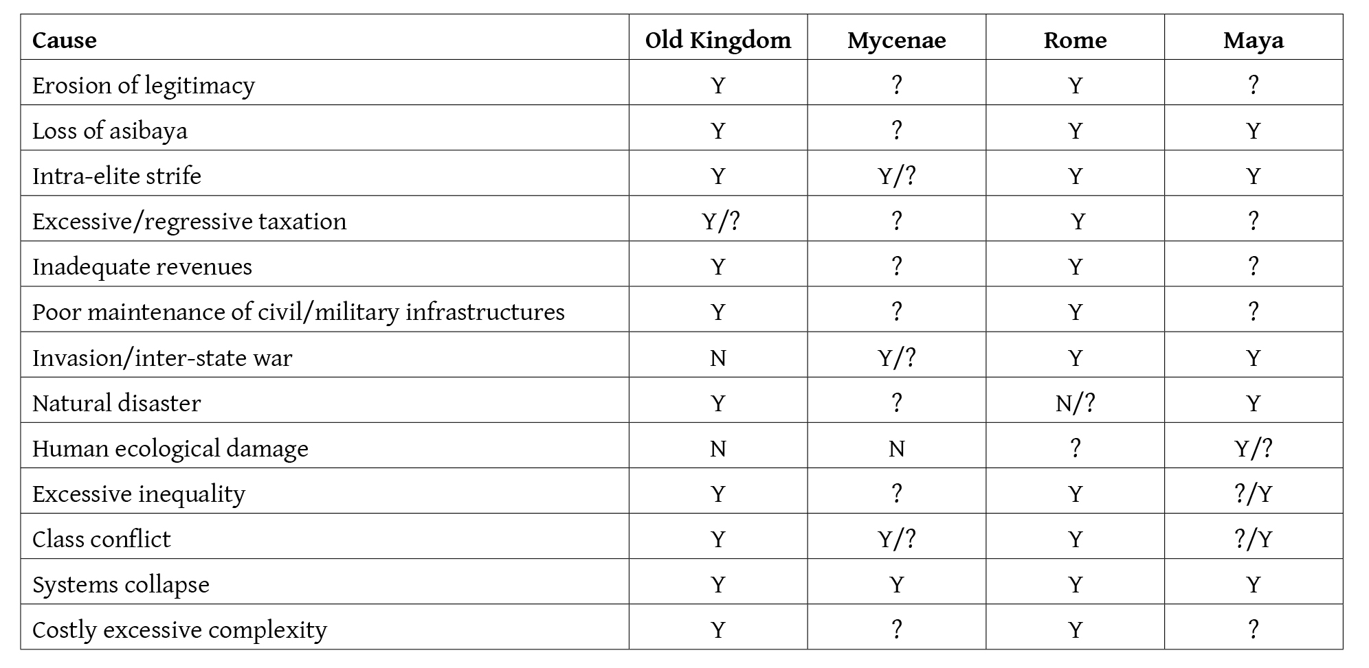
Collapse should be explained as failure to fulfil the ancient state’s core functions: assurance of food supplies, defence against external attack, maintenance of internal peace, imposition of its will throughout its territory, maintenance of key civil and military infrastructures, enforcement of state-wide laws, and promotion of an ideology to legitimise the political and social status quo.
To fulfil these functions certain necessary conditions must be met. The legitimacy of the political and social status quo, including the distribution of political power and wealth, needs to be accepted; the state should be able to extract sufficient resources to fulfil its functions such as defence; it must be able to enforce its decisions; the ruling elite should share a common purpose and actions; the society needs to reflect a shared spirit (asibaya) and purpose across elites and commoners who believe it is worthy of defence.
Weaknesses and failure to meet any condition can interact to exacerbate the situation: maladministration, corruption and elite preoccupation with self-aggrandisement can induce fiscal weakness, reduced military budgets and further invasion; it can induce neglect of key infrastructures (especially water management). Inequality, a commonly neglected factor despite ancient texts, can erode asibaya and legitimacy and alienate commoners from defence of the state.
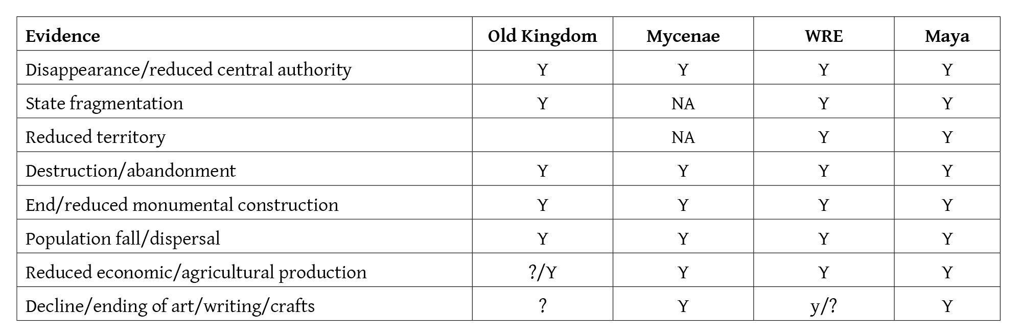
These themes are explored in relation to the Egyptian Old Kingdom, Mycenae, the Western Roman Empire (WRE), and the Maya. They all exhibit, to varying degrees, weaknesses in meeting the above conditions necessary for stability.
Although political collapse of the Old Kingdom is definite there is no consensus on the scope and severity of economic and cultural collapse. Drought, famine and intra-elite strife have been suggested as explanations for political collapse. Mass alienation and violence against the ruling elites has been suggested in ancient texts but their credibility is contentious. The evidence suggests systems failure and dysfunctionality including the incompetence and collapse of central authority and intra-elite strife (not least centre-provincial conflict); failure to finance and maintain key water management infrastructures by elites focussed on self enrichment; drought, the effects of which were exacerbated by that failure; loss of asibaya induced by huge inequality and the behaviour of selfish elites; and social conflict, possibly violent; loss of royal legitimacy in the face of drought despite the king’s supposed divine ability to guarantee rainfall and Nile flooding.
The political collapse of the Mycenaean palace states is beyond dispute. Some but not all aspects of their civilisation vanished. However, explanations of their political collapse (internal social strife including a Dorian peasant uprising, drought, invasion by Sea Peoples, earthquakes, intra-elite and interstate violent competition, and barbarian military technological advance) are particularly speculative because the very existence of possible explanatory factors is poorly demonstrated in the archaeological and written record, Homeric myth notwithstanding. Elements of the culture survived (religion, spoken language, some luxury artefact production) but others vanished, especially Linear B writing.
The WRE was dismantled by successive “Barbarian” invasions which should be regarded as factors in a dynamic systems collapse: unstable, ineffectual, corrupt governments, dynastic rivalry, intra-elite strife, economic and fiscal weakness and reduced military budgets induced barbarian invasion which further reduced the tax base and military funding. Aggressive imperial expansion itself had induced Germanic tribal coalescence which then exploited emerging Roman weakness and dismembered the WRE. The collapse graphically illustrates failure to meet the conditions needed for stability: effective defence against external attack, robust public finances, intra-elite cohesion, a society-wide spirit of asibaya – whereas the peasantry were impoverished and some collaborated with barbarian invaders or participated in Bacaudae armed rebellion ( the significance of which is disputed), commoner and elite acceptance of the legitimacy of the ruling regime, including willingness to support the state in the face of external attack.
The collapse of classic Maya states embraced the end of a political system and material culture but at different times in different places. Violent dynastic and intra-elite strife are probably sufficient to explain collapse; but they would have contributed to ineffectual responses to climate change, especially drought. Great inequality and peasant grievance, illustrated in ancient texts and by defacement of elite structures might suggest uprisings but such attacks on rich buildings and monuments might have followed collapse attributable to other reasons. Droughts arose at different times in different locations, although agriculture seems to have continued in some arid areas and evidence of drought in one place cannot explain collapse elsewhere. In short, ineffective government associated with internal strife along with droughts induced collapse but their relative contributions probably varied across the Maya states.
Inequality
Despite assertions by Aristotle and De Tocqueville that inequality is a factor in collapse, no analysis of inequality as an explanation of ancient collapse has been attempted or even suggested in recent publications on either ancient inequality or collapse. Evidence of inequality exists: house and skeletal size, and grave goods demonstrate ancient inequality. But grievance induced by inequality alone is insufficient to provoke successful challenge to authority; leadership, organisation and resources are also needed. They were conceivably provided by the WRE Bacaudae but their role in WRE collapse is disputed although written evidence suggests discontented peasants sometime welcomed and assisted barbarian invaders. Violence by the poor is suggested as a factor in Old Kingdom and Mycenaean collapse but the evidence is disputed in both cases. Minoan and Mayan evidence of damage to elite property exists but it is not known whether this preceded or followed collapse of authority. One Pueblo study demonstrates lagged correlation between peak inequality and peak violence but no examination of possible socially differentiated skeletal trauma was undertaken. Such research could produce useful evidence of possible social strife as a factor in collapse. Lack of such evidence could indicate lack of interest in inequality’s contribution to collapse or its genuine unavailability.
Conclusions
The distinction between states and societies or cultures is essential: the former, political entities can collapse but not necessarily the latter so to deny state collapse because of the continuation of cultural elements misses the point.
Mono- causal explanations of collapse are inadequate but to acknowledge multi-causality is insufficient unless a dynamic interaction between various explanatory factors is recognised.
States collapsed when they failed to fulfil their core functions because they did not meet the conditions necessary for a functioning stable state. Such pre-conditions include legitimacy, a common spirit of asibaya, ability to extract sufficient resources to maintain key infrastructures and services, intra-elite cohesion, and the ability to enforce decisions across its territory.
Hans de Zeeuw introduces the tanbûr long-necked lute
In contemporary Turkey, the saz or bağlama, being a member of a large family of long-necked lutes called tanbûrs, is the core instrument of all folk musical ensembles and orchestras and a popular instrument in the arabesk, entertainment, and pop music in Turkey. The bağlama also plays an important role during the ceremonies of the heterodox sects of the Alevî and Bektaşî and among the âşıks, the Anatolian wandering poet-musicians, to accompany their partly religious repertory. The bağlama plays furthermore an important role in musical education to teach folk-music theory, notation, performance, and teaching of acoustics and instrument construction. Its importance is also testified by the fact that musicians, such as Arif Sağ, Musa Eroğlu, and Erdal Erzincan, play the bağlama as solo instrument on national and international concert stages.
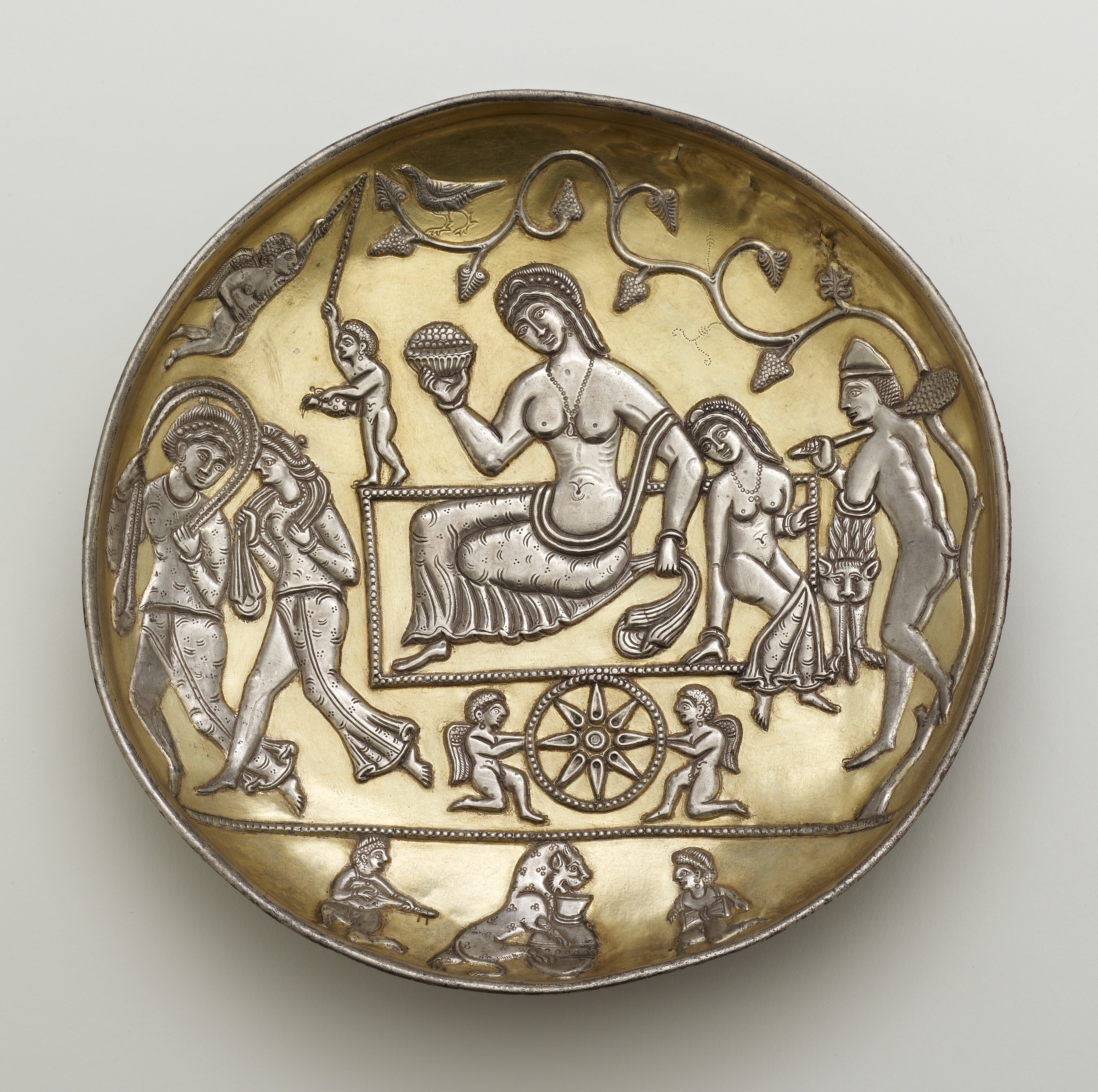
The long-necked tanbûr, which appeared in literary and iconographic sources during the Sâsânian era (c. AD 224-651), diffused into the various musical traditions along the Silk Road, resulting in a variety of closely or distantly related tanbûrs with two or more, occasionally doubled or tripled courses, a varying number and variously tuned frets, each having its own characteristic sound, playing technique, and repertory. Similar or identical instruments are also known by other names, such as saz or bağlama, dotâr or dutâr, setâr, dömbra, and damburâ (FIGURE 1).
Figure 1. Sâsânian silver plate showing a poet-musician playing a tanbûr, 5th–7th centuries AD (bottom left). Freer Gallery of Art, Washington.
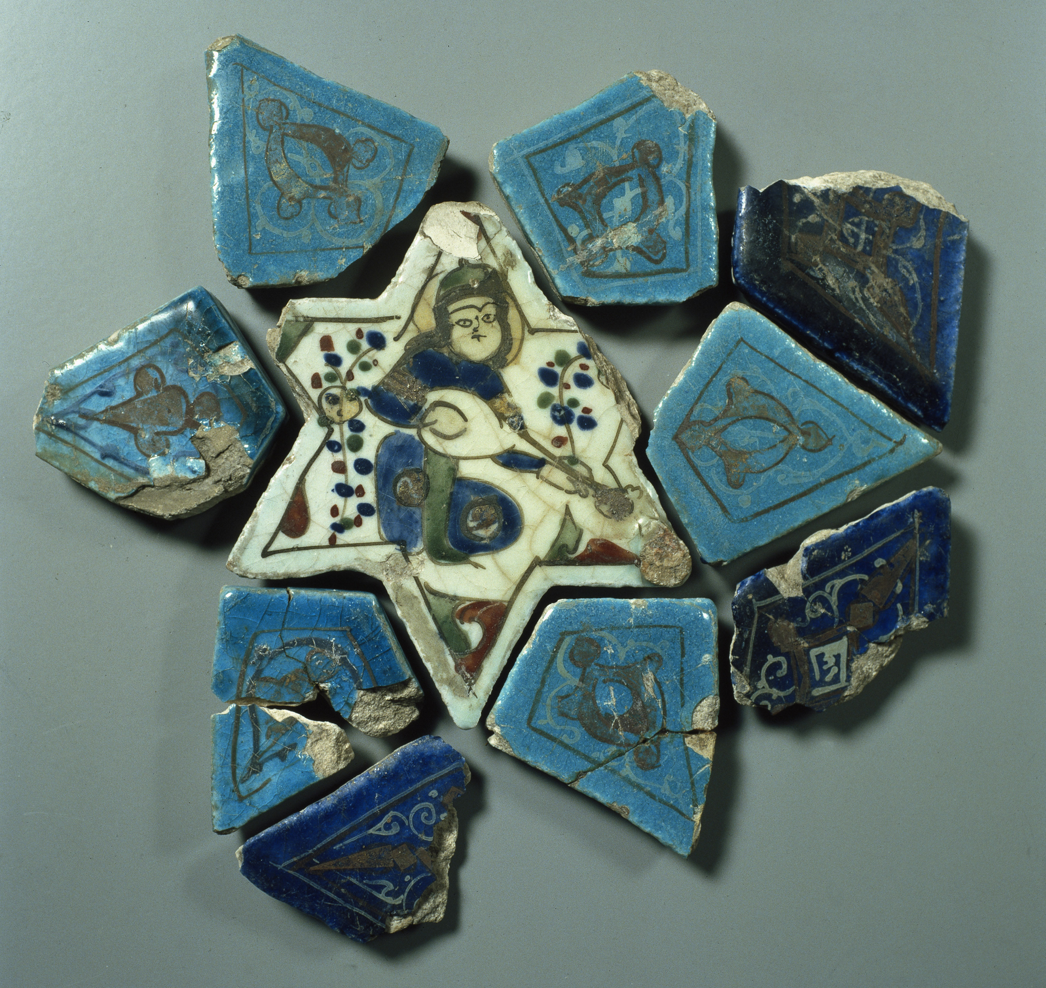
The tanbûr arrived with the Seljuks in Anatolia in the eleventh century or even may be before. Possible intermediaries in the development of the Turkish saz instruments are the by Abd al-Qâdir Ibnu Ghaibî al-Marâghî in his book Maqâsid al-Alhân (The meaning of melodies, early fifteenth century) discussed tanbûr-i şirvânîyân (the tanbûr of Shirwân, located in the north of Azerbaijan) and the tanbûre-i türkî (the tanbûr of the Turks). The tanbûre-i türkî had, compared to the tanbûr-i şirvânîyân, a smaller pear-shaped body, a longer neck and two or three strings (FIGURE 2). Saz is a Persian word meaning musical instrument. It appeared for the first time in a work by Nezami van Gandja (1141-1209), one of the greatest poets in Persian poetry. In Anatolia we come across the word saz in the fifteenth century as a name for the tanbur of the travelling poet singers, the âşık, who were also called saz şaileri, poets with the saz.
Figure 2. Poet-musician playing a tanbûr in the usual cross-seated playing position of Central Asia with the neck pointed downwards, like the tanbûr players on the Sâsânian silver plates, on an excavated ceramic tile from the summer palace of Sultan Alâ al-Dîn Kayqubâd I, Anatolia, early 13th century. Museum für Islamische Kunst, Staatliche Museen, Berlin.
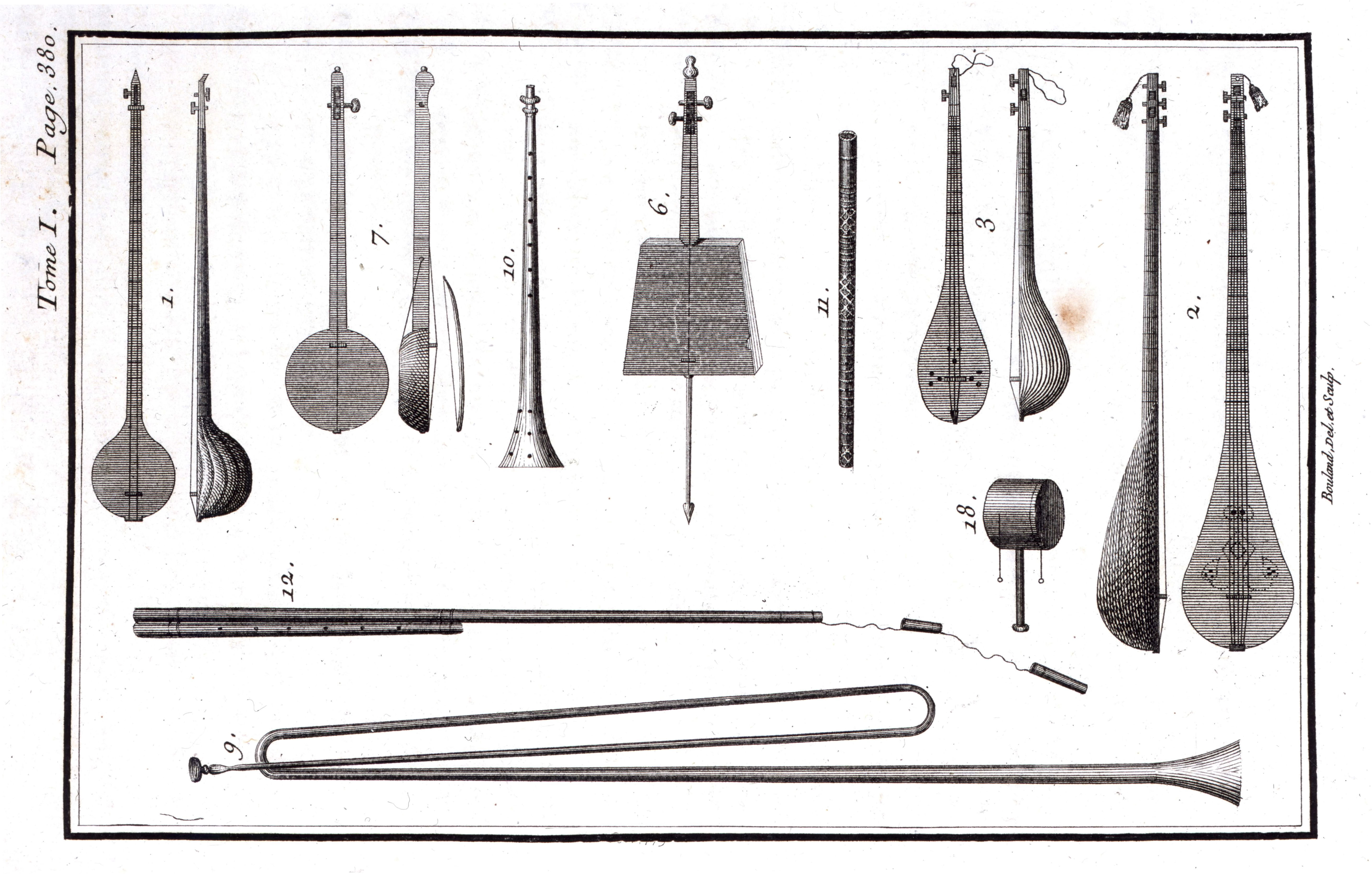
The origin of the name bağlama is still unknown. It could have been derived from the verb bağlamak (Turkish for to bind), the tying of frets around the neck or strings to the tuning pegs. The description of a saz with the name bağlama appeared in the second half of the 18th century in several European writings. Histoire générale, critique et philologique de la musique (1767) by Charles-Henri de Blainville (1711-1769), Reisebeschreibung nach Arabien und andern umliegenden Ländern (1774, 1778) by Carsten Niebuhr (1732-1815), and Essai sur la musique ancienne et moderne (1780) by Jean Benjamin de Laborde (1734-1794), who was sentenced to the guillotine during the French Revolution. De Blainville and Niebuhr were probably the sources of de Laborde. The bağlama was a small sized lute compared to the other lutes on the engravings of de Blainville, Niebuhr, and de Laborde (FIGURE 3).
Figure 3. Bağlama (3), bozuk (2), and iki telli (1) on an engraving from the Essai sur la musique ancienne et moderne of Benjamin de Laborde.
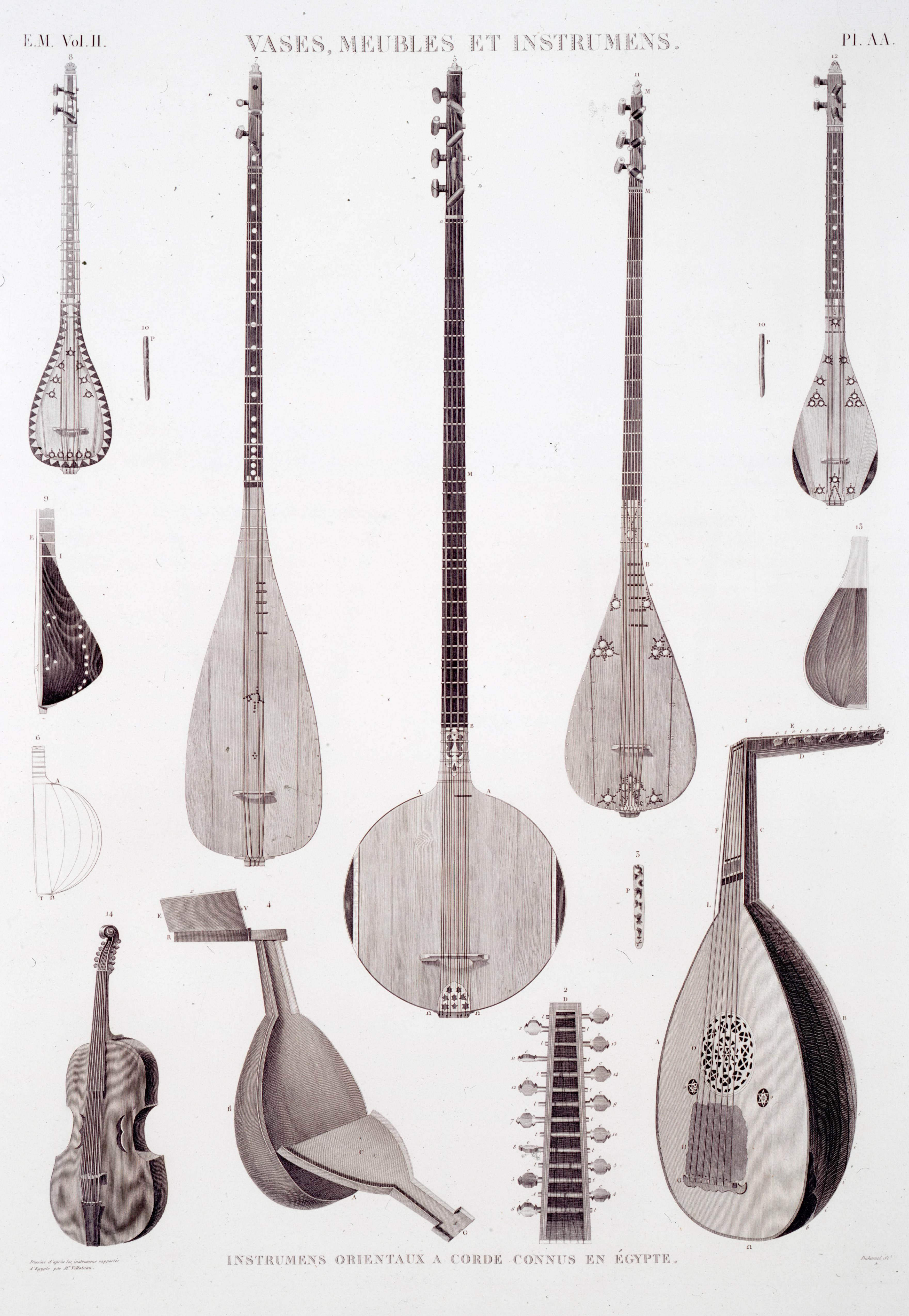
A few decades later we find the name bağlama as tanbour baghlama in another European writing Description historique, technique et littéraire des instruments de musique des orientaux of 1823 by Guillaume André Villoteau. Villoteau, who stayed in Cairo from 1799 until 1803 as a member of Napoleons Egypt-expedition, discussed several tanbûrs, which were mainly played by Turks, Jews, Greeks, and Armenians. In Lane’s time (1830s), tanbûrs were still ignored by native musicians in Egypt and only played by Greeks and other foreigners (FIGURE 4).
Figure 4. The Ottoman tanbûr (tanbour kabyr tourky) in the centre is flanked on the left by the tanbour charqy and the small tanbour boulghâry and on the right by the tanbour bouzourk and the small tanbour baghlama. Furthermore, in the foreground, a violin and a ‘ûd, engraving from the Description historique technique et littéraire des instruments de musique des orientaux (1823) of Guillaume André Villoteau.
We know from the Seyâhatnâme of Evliyâ Çelebi that sazs, which travelled with the Ottomans to the Middle East and the Balkans, were present at the Ottoman court and in the Turkish cities. Literary and iconographic sources as well as surviving instruments to reconstruct the history of the saz in the rural areas of Anatolia before the 20th century are scarce or absent. The separation between urban and rural culture was mirrored by the sophisticated courtly and urban sazs and the simple rural sazs, a situation that only increasingly changed after the establishment of the Republic of Turkey in 1923.
The proclamation of the Republic of Turkey in 1923 in Ankara had a major impact on the musical traditions and musical instruments of which the modernized and standardized saz became the most important instrument. In the 1930s musicologists started to construct a theory of folk music parallel to that of the Ottoman makam tradition. A body of modal structures, instrument tunings, plectrum movements, and rhythms were established through collection and notation inseparably linked to the saz. Moreover, the number of tied-on movable frets was, in imitation of the Ottoman tanbûr, increasingly expanded to create a larger tonal range. An earlier example of this practice can be found on a drawing of a saz from the Tefhîmü’l Makamat fi Tevlîd-in Neğamât (The concept of the makams in the making of melodies, mid-18th century) of Kemânî Hızır Ağa.
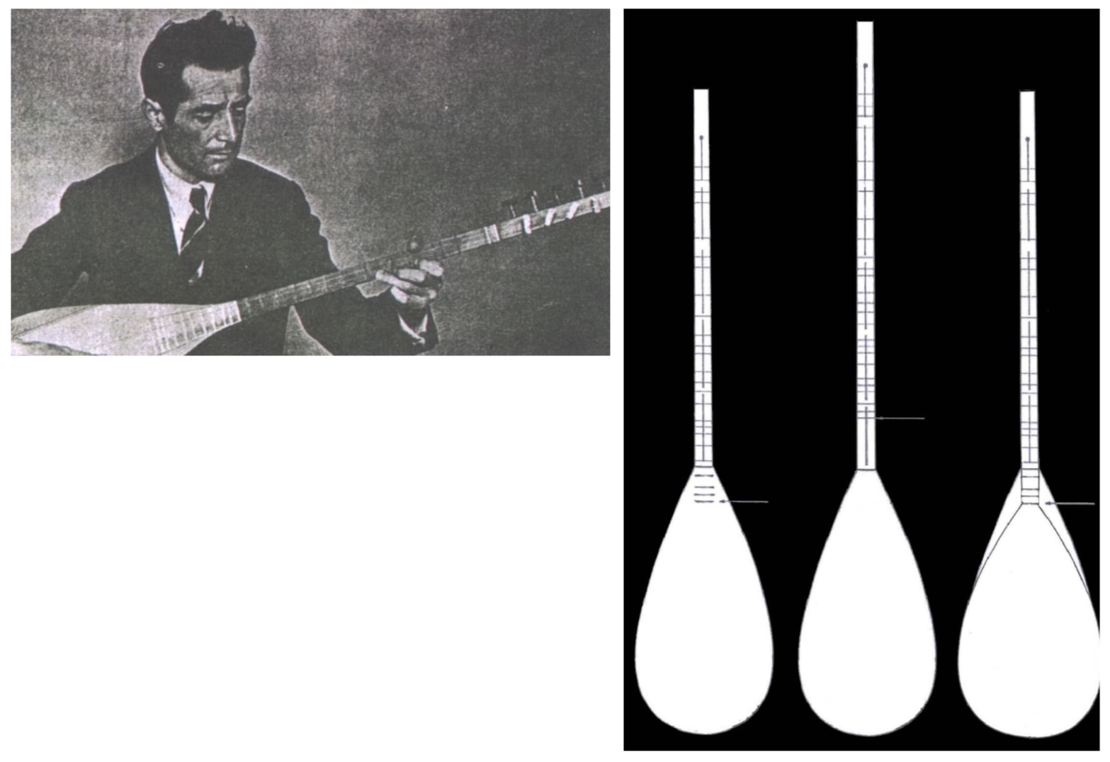
Around 1940, the number of frets further increased, a development in which Mahmut Ragıp Gazimihâl (1900-1961) and Muzaffer Sarısözen (1899-1963) played an important role. This development took place around Radio Ankara and aimed to reform the music and musical instruments of the many regions, each with their own characteristics, into a coherent whole. For that purpose, choirs and orchestras were established, which performed uniform folk music on standardized sazs like those of Radio Ankara and Radio Istanbul.
Since the 1950s it became increasingly customary, starting in radio circles, to use the name bağlama instead of saz as a generic name for saz instruments. From literature we learn, however, that the traditional bağlama of Anatolia was a small saz. It is therefore obvious that not the small bağlama, but a larger saz was used to expand the number of frets. In contemporary Turkey, bağlama and saz are still used alternately.
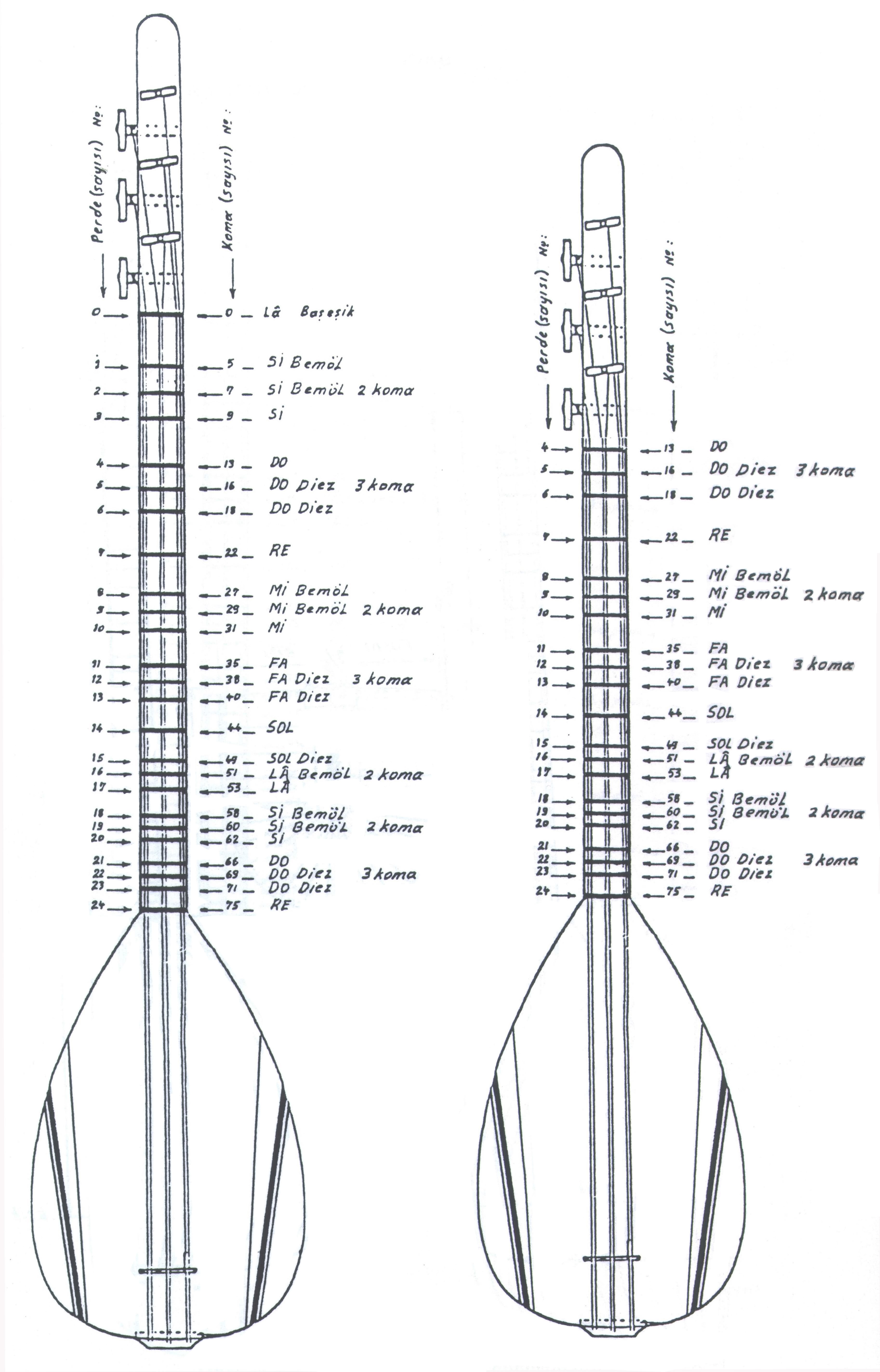
Figure 5. Fret tuning (perde taksimati) of the long-necked bağlama (uzun saplı bağlama) and short-necked bağlama (kısa saplı bağlama) according to Cafer Açin.
Due to the modern entertainment industry and the changing taste of the audience after 1960, better trained musicians developed virtuoso playing techniques and set higher demands on technical and artistic issues such as the timbre and sound volume of their instrument, the method of stringing, and the number of frets and their arrangement on the neck. Around 1970 there was still a great variety in the number of frets and their tuning. Nail Tan concluded in Bağlama yapımı (Bağlama construction) that generally seventeen frets were used for the octave, but that the number of frets, among which non-diatonic ones, and their position on the neck was not yet standardized. Since second half of the 1980s, there seems to be some agreement. Sabri Yener in Bağlama öğretim metodu (Bağlama teaching method) and Irfan Kurt in Bağlamada düzen ve pozisyon (Bağlama tuning and vertical technique) both established seventeen frets in the octave, including five non-diatonic frets. Cafer Açin (1939-2012) established in Bağlama. Yapım sanatı ve sanatçıları also seventeen frets in the octave for the long-neck bağlama as well as short-neck bağlama (FIGURE 5).
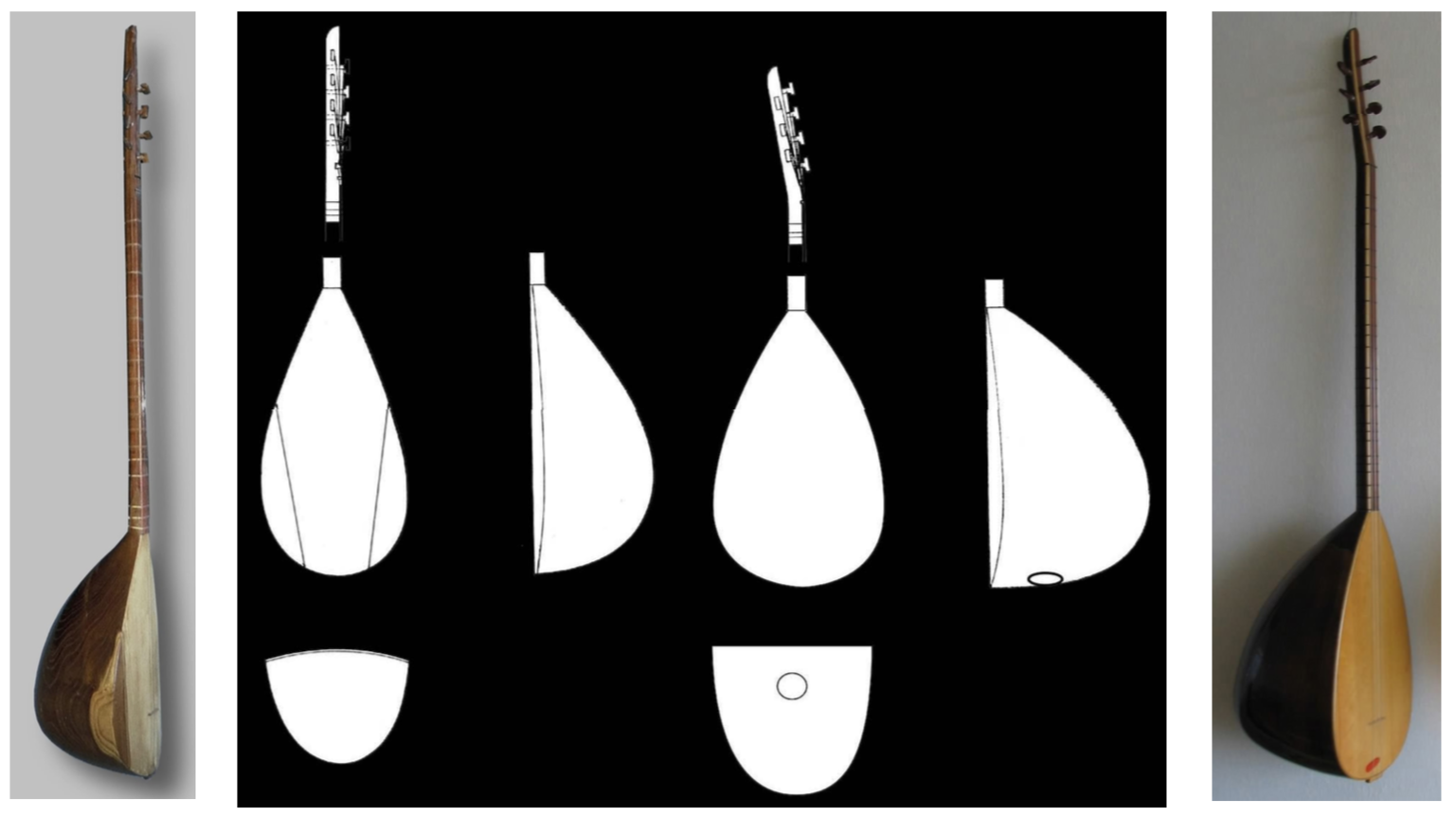
The development of virtuoso playing techniques consisted of an increasing combination of vertical and horizontal playing techniques on the bağlama. In order to make an effective use of its vertical possibilities, the neck had to be shortened. By constructing a more pear-shaped bowl it was possible to lengthen the neck inwardly. In this way, the neck could be kept relatively short keeping the necessary space for the frets (FIGURE 6).
Figure 6. On the left, Muzaffer Sarısözen playing a ten-stringed of which the number of frets are expanded on the soundboard. On the right, the expansion of the number of frets on the neck by modifying the bowl of the saz.
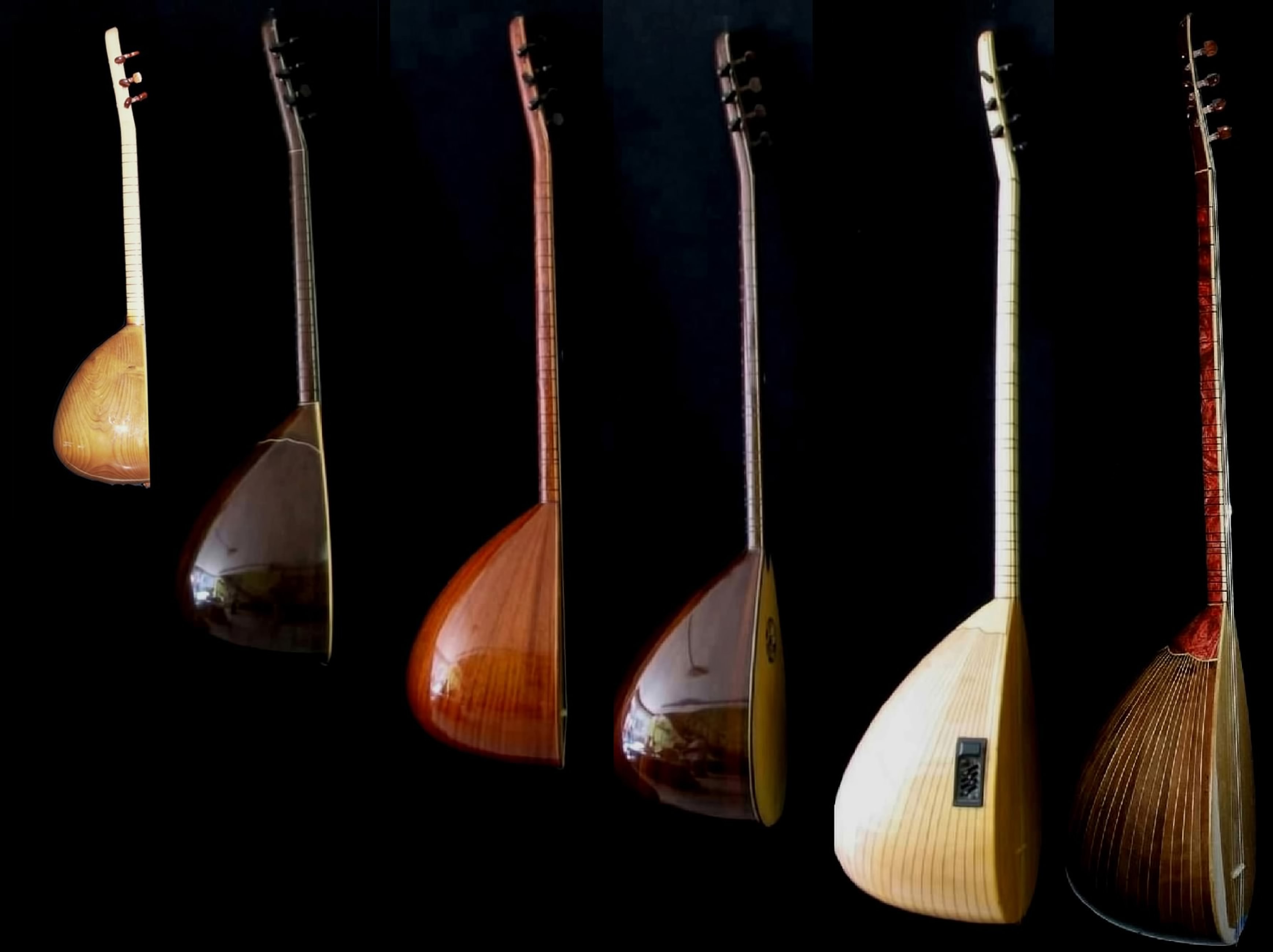
Modern entertainment required, furthermore, the amplification of the sound. The bowl was therefore changed from a small U-shape to a larger and deeper U-shape with a soundhole (kafes) under the tailpiece (tel bağlama takozu) or, sometimes, in the soundboard. The soundboard changed from slightly arched and composite to a flat one made of a singular sheet of wood. For constructional reasons, the characteristic straight pegbox of the saz was replaced by a slightly angled attached pegbox. Moreover, on the first, third, and sometimes second course one of the strings was replaced by a so-called ‘bam teli’ or ‘octave’ string (brass-wrapped string), which was introduced towards the end of the 1950s by Neşet Ertaş (1938-2012) who was probably the last of the great bozlak (songs of agony) poet-musicians. These changes increased the soundvolume and changed the timbre. Moreover, the bağlama was amplified with electronic devices to facilitate playing in clubs or concert halls (FIGURE 7).
Figure 7. On the left, traditional saz. In the middle, morphological modifications of the soundbox, soundboard, and pegbox of the saz. On the right, contemporary long-necked bağlama.
The ongoing development of virtuoso playing techniques, combining the traditional horizontal playing techniques with vertical playing techniques, fuelled the development of the short-necked bağlama, being actually a long-necked bağlama with a shortened neck, an instrument suiting the combining of vertical and horizontal playing techniques. To distinguish the long-necked bağlama from the short-necked bağlama, the long-necked bağlama was called unzun saplı bağlama, the short-necked bağlamakısa saplı bağlama. The first experimental versions of the short-necked bağlama emerged after 1960. Musicians were, before Arif Sağ asked the luthier Kemal Eroğlu to develop a short-necked bağlama, not very interested in the short-necked bağlama. According to Kemal Eroğlu, the short-necked bağlama was derived from the long-necked saz/bağlama. According to Arif Sağ, however, the short-necked bağlama was not a new development but an older type saz type with a short neck. Some agree that there are certain similarities with the saz of the Alevî dedes.
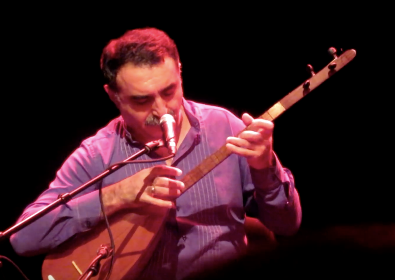
The short-necked bağlama became after 1980, mainly under the impulses of Arif Sağ, a very popular instrument, particular in combination with the şelpe and parmak vurma technique (see accompanying video of Erdal Erzincan). An example is his virtuoso Teke Zotlaması, which was also played by Talip Özkan (1939-2010) on the long-necked bağlama as well as cura bağlama. Talip Özkan started in the 1960s to combine the traditional horizontal playing technique with vertical playing techniques on the long-necked bağlama tuned to the bozuk düzeni tuning, a tuning facilitating both techniques (FIGURE 8).
Figure 8. On the left, Arif Şağ playing şelpe on the kısa saplı bağlama during a concert in the Tropeninstituut in Amsterdam. Foundation Kulsan, Amsterdam. On the right, Talip Özkan playing a long-necked bağlama combining horizontal and vertical playing techniques.
Many folk musical genres can be played on the long-necked bağlama because it can be tuned in various ways. The short-necked bağlama has, on the other hand, a higher sound volume and can, because of its shorter neck and closely spaced frets, be played ‘easier’ and faster making use of all the three courses. Despite its popularity the short-necked bağlama did, however, not displace the long-necked bağlama.
Modernization and standardization resulted, furthermore, in the 1980s in the in the bağlamafamily (bağlama ailesi). Within the bağlamafamily different size categories can be distinguished, although no single classification is in general accepted and there are, moreover, also intermediate forms. A possible classification of the bağlamafamily, from small to large, is the cura, the short-necked bağlama (kısa saplı bağlama) and the long-necked bağlama (uzun saplı bağlama), the tanbura, the divan sazı, and the meydan sazı. The establishment of a nomenclature of the saz/bağlama family still has to be undertaken (FIGURE 9).
Figure 9. The bağlama family consisting of the cura, the short-necked bağlama (kısa saplı bağlama) and the long-necked bağlama (uzun saplı bağlama), the tanbura, the divan sazı, and the meydan sazı.
The systematic use of all three string courses and making a more effective use of the bağlama düzeni not only resulted in the short-necked bağlama but also initiated the development of instruments such as the dört tellibağlama (four course bağlama) and Oğur sazı, developed by the luthier Kemal Eroğlu after an idea of the musician Erkan Oğur. Both instruments are a continuation of the development of vertical and harmonic playing techniques (FIGURE 10, left).
Since the first six-stringed prototype from 1991, more prototypes were built like the thirteen-stringed and six-stringed Oğur sazı. In the meantime, various versions of the Oğur sazı were built by among others the musician and luthier Engin Topuzkanamış (Izmir) for other musicians like Efrén López and Guillermo Rizotto in Spain and Gilad Weiss in Israel (FIGURE 10, right).
Figure 10. On the left a four-course dört telli bağlama by Murtaza Çağır and ten-stringed Oğur sazı by Engin Topuzkanamış. On the right Engin Topuzkanamış playing a six-stringed version of the Oğur sazı in his workshop in Izmir.
An example of how the bağlama can inspire new forms is the divane of Yavuz Gül. Looking for a larger volume than the divan sazı, Yavuz Gül (Izmir) developed the divane, a family of hybrid instruments inspired by the long-necked bağlama and ‘ûd/lauta. The divane family consist of the efe divane, baba divane, divane deli, and the bass divane (FIGURE 11).
Figure 11. Three-course divane played by Yavuz Gül.
The exploration and development of vertical and harmonic playing techniques and a theory of Turkish harmony, for which the bağlama provides a model, will remain an important issue within Turkish folk music, notwithstanding attempts to standardization. Instrument makers do respond to the changes in the musical practice. This principle has dictated the evolution of music and instrument making for centuries.
Figure 12. Erdal Erzincan playing şelpe on a for this technique made four-stringed bağlama during a concert in the Centrale in Gent in 2017. The Centrale, Gent (Belgium).
Musical instruments are constantly changing and there is always room for improvement, innovation, and evolution. New bağlama types, of which the construction, the number of frets and their tuning, number of strings and their tuning, and playing technique vary, will therefore continue to evolve (FIGURE 12).
Further Reading
Bates, E. 2011. Music in Turkey: Experiencing Music, Expressing Culture (Global Music Series). Oxford: Oxford University Press.
Conway Morris, R. 2001. Bağlama, in S. Sadie (ed.) New Grove Dictionary of Music and Musicians 2: 469. London: MacMillan Press Limited.
Hassan, S.Q., R. Conway Morris, J. Baily and J. During 2001a. Tanbūr, in S. Sadie (ed.) New Grove Dictionary of Music and Musicians 25: 61-62. London: MacMillan Press Limited.
Sayce and T. Crawford 2001. Lute, in S. Sadie (ed.) New Grove Dictionary of Music and Musicians 15: 329-363. London: MacMillan Press Limited.
Spector, J., R. At’Ajan, C. Rithman C and R. Conway Morris 2001. Saz, in S. Sadie (ed.) New Grove Dictionary of Music and Musicians 22: 361-362. London: MacMillan Press Limited.
Stokes, M.H. 1993. The Arabesk Debate. Music and Musicians in Modern Turkey. Oxford: Claredon Press.
Zeeuw, J. 2009. De Turkse Langhalsluit of Bağlama. Amsterdam.
Zeeuw, J. 2019. Tanbûr Long-Necked Lutes along the Silk Road and beyond. Oxford: Archaeopress.
Stefano Anastasio and Barbara Arbeid present the photo-archives of archaeologist and photographer John Alfred Spranger (1889-1968)
The importance of early photo-archives for archaeology
Early photo archives are becoming an increasingly important source of information for archaeology. This is, of course, a positive trend: any effort to make “forgotten” data available to the scientific community is to be welcomed.
Early photos may prove a powerful tool for protecting and promoting the value of archaeological heritage.
Hopefully, the current interest in early photo-archives will result in an increasing number of published archives. This will help archaeologists enhance their research, as well as the protection and conservation of the archaeological heritage.
John Alfred Spranger
John Alfred Spranger was born in Florence on 24 June 1889. His father, William, moved to Tuscany from England in the middle of the nineteenth century and was a professor at the Academy of Arts and Drawings in Florence. John Alfred was a leading figure in the cultural milieu of Florence at the beginning of the twentieth century. Both archaeologist and photographer (as well as engineer, topographer, mountain climber, art collector…), he was the author of several photo reportages detailing archaeological monuments and landscapes especially in Italy, Albania, Greece, Canada, Egypt, and Mesopotamia.
In 1913-1914, he participated in the Filippo De Filippi Expedition to the Himalayan Karakoram, as assistant topographer. The photographers of the expedition – Cesare Antilli, Major of the Italian Army, and Giorgio Abetti, a Florentine astronomer – systematically used cameras during the expedition, creating a real reportage, and Spranger surely gained a great passion for photography thanks to this expedition.
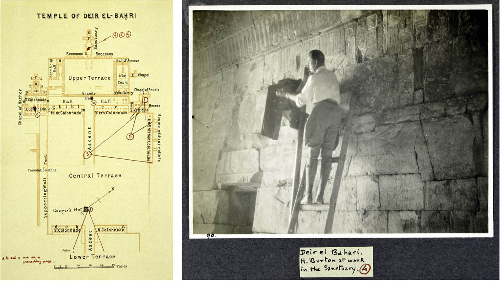
Fig. 1. Harry Burton at work in Deir el-Bahari (1929). The photo on the right corresponds to no. 4 marked on the map.
In the 1920s-1930s, he took part in a number of Etruscan excavations in Tuscany and paid great attention to the use of the camera to document the excavation work in progress. During this period, he spent time with Harry Burton, photographer of the discovery of the Tomb of Tutankhamun. It was, in fact, in Florence that Burton was hired as a photographer and archaeologist by Theodore M. Davis, who obtained the concession for the excavations in the Valley of the Kings in Egypt. During his stay in Florence, Burton spent time with Spranger and both were involved together in a number of Etruscan excavations. Their friendship is witnessed by Spranger in his Egyptian album, where Burton is portrayed in some photos taken in 1929 during the excavations at Deir el-Bahari (see fig. 1). Spranger died in 1968 at Newbury, in England, and was buried in Florence.
The publication of Spranger’s photo-archives
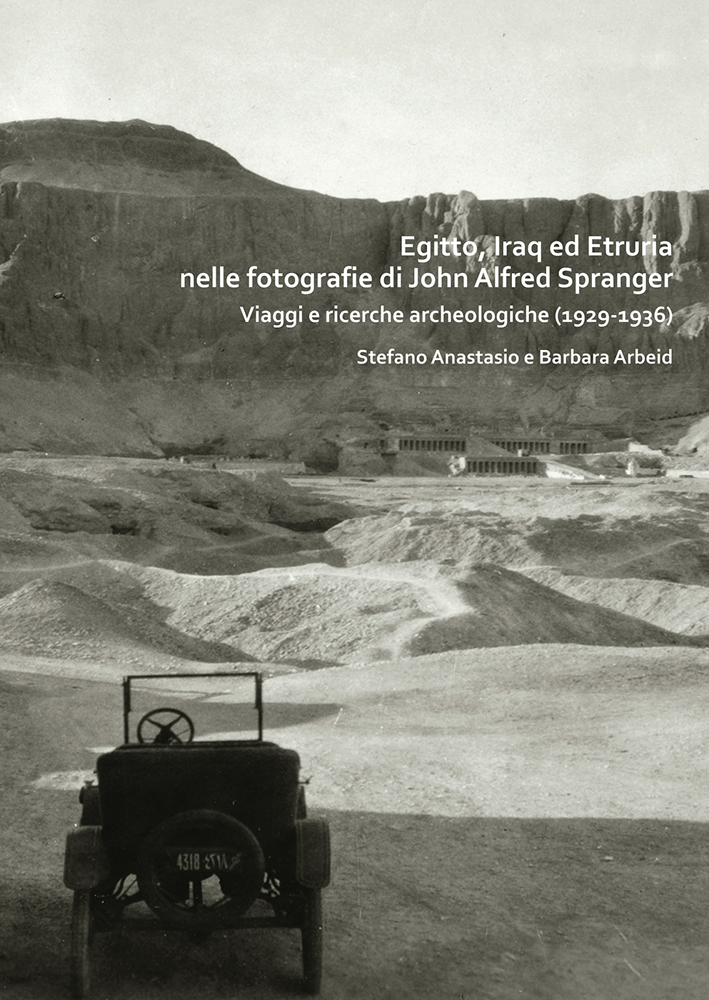
The passion for photography accompanied Spranger for life. He took thousands of photographs, collecting them in refined photo-albums, consistent in shape, size and style, enriched by annotations, topographic maps and plans (most of the original stereograms were recently retrieved at the public library of Vaiano, a small town close to Florence where many documents from Spranger’s family are held today). On Spranger’s death, some albums, i.e. those dedicated to “archaeological subjects” were donated by his heirs to the then Superintendency of Antiquities of Etruria, and are currently held at the Photo-Archive of the Archaeological Museum of Florence. The volume published by Archaeopress presents the photos dedicated to a trip to Egypt in 1929 and a trip to Mesopotamia (Iraq) in 1936, as well as to some surveys and excavations carried out in Etruscan archaeological sites in Tuscany between 1932 and 1935.
Fig. 2. The map of the témenos of Ur (1936), with the photo perspectives and camera angles marked and numbered. On the right, photos corresponding to no. 3 (ziqqurat, from NE) and no. 8 (ziqqurat and courtyard of Temple of Nannar, from N).
Spranger’s photos are particularly meaningful, especially because he combined his skills in using the camera with a great expertise in archaeology and topography. He often glued maps of the sites he had surveyed on the albums, on which all perspectives and camera angles were marked and numbered (see an example in fig. 2). As a result of this, he was able to create outstanding “georeferenced” sets of photos for many archaeological sites: Giza, Heliopolis, Menphis, Saqqara, Beni Hasan, Abydos, Dendera, Medinet Habu, Karnak, Luxor, Thebes and Deir el-Bahari, in Egypt; Ur, al-Ubaid, Uruk, Nippur, Babylon, Ctesiphon and Birs Nimrud in Mesopotamia; the tholos of Casaglia, the tumulus of Montefortini and the necropolis of Casone, Riparbella, La Ripa in Tuscany.
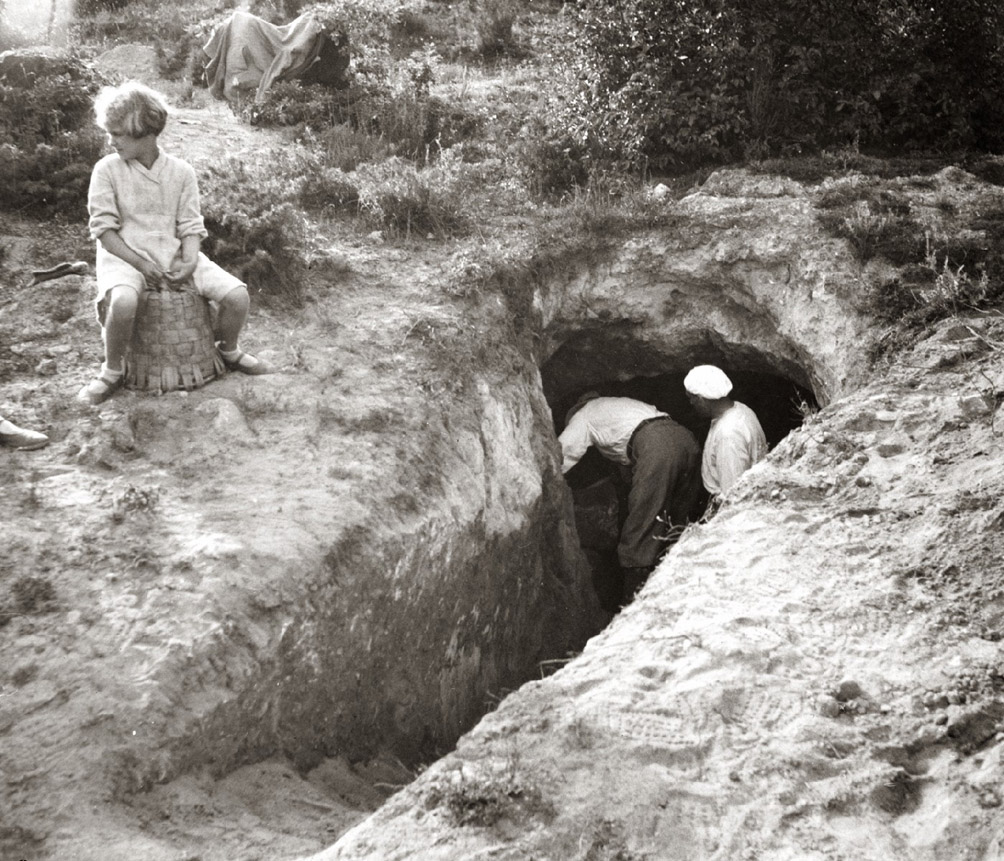
Fig. 3. Excavation of a tomb at the necropolis of La Ripa, in Tuscany (1933).
Cover photo: Page from an album dedicated to the temple of Seti I in Abido, Egypt. On the left is the temple plan, with perspectives and camera angles numbered so as to allow identification of the related photographs, in turn numbered and placed on the right page.
About the authors Stefano Anastasio has carried out archaeological researches in Italy (Sardinia, Tuscany), Syria, Turkey, Jordan and currently works at the Archaeological Photo Archive of the Superintendency of Florence. His main research interests are the Mesopotamian Iron Age pottery and architecture, the building archaeology and the use of the early photo archives for the study of the Near Eastern archaeology.
Barbara Arbeid is an archaeologist at the Superintendency of Florence, appointed to the archaeological heritage protection service. Her main research interests are the archaeology of Norther Etruria, the Etruscan bronze craftsmanship, the archaeological collecting and photography.
Further reading
Egitto, Iraq ed Etruria nelle fotografie di John Alfred SprangerViaggi e ricerche archeologiche (1929-1936) by Stefano Anastasio and Barbara Arbeid. Archaeopress Archaeology, Oxford, 2019.
205x290mm; 178 pages; highly illustrated throughout in sepia and black & white. Italian text with English summary.
Paperback: ISBN 9781789691269. £35.00.
eBook: ISBN 9781789691276. From £16.00 (+VAT if appl.).
Also available from Archaeopress
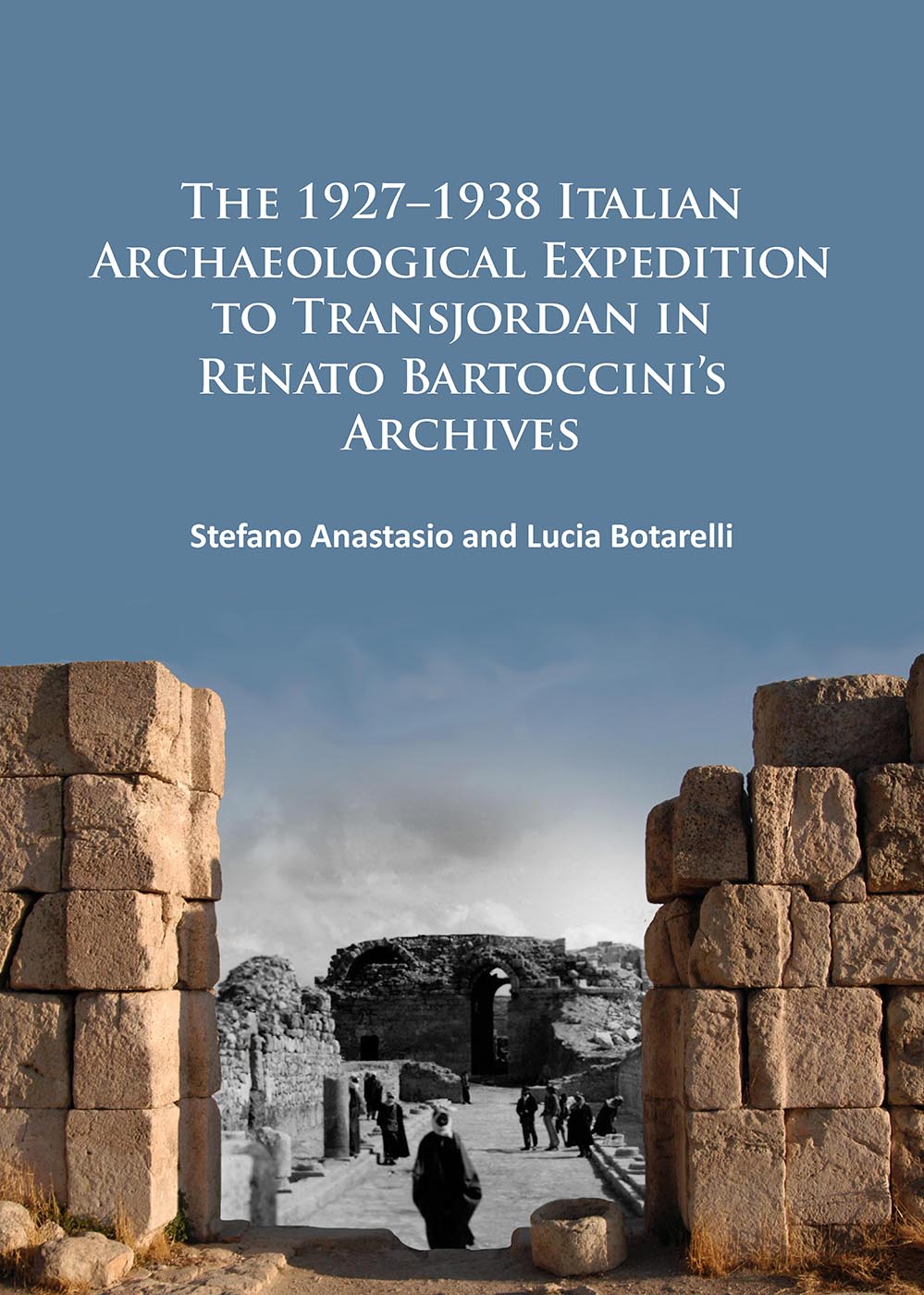
The 1927–1938 Italian Archaeological Expedition to Transjordan in Renato Bartoccini’s Archives by Stefano Anastasio and Lucia Botarelli. Archaeopress Archaeology, Oxford, 2015.
210x297mm; ii+242 pages; extensively illustrated throughout in black & white.
Paperback: ISBN 9781784911188. £40.00.
eBook: ISBN 9781784911195. From £16.00 (+VAT if appl.).
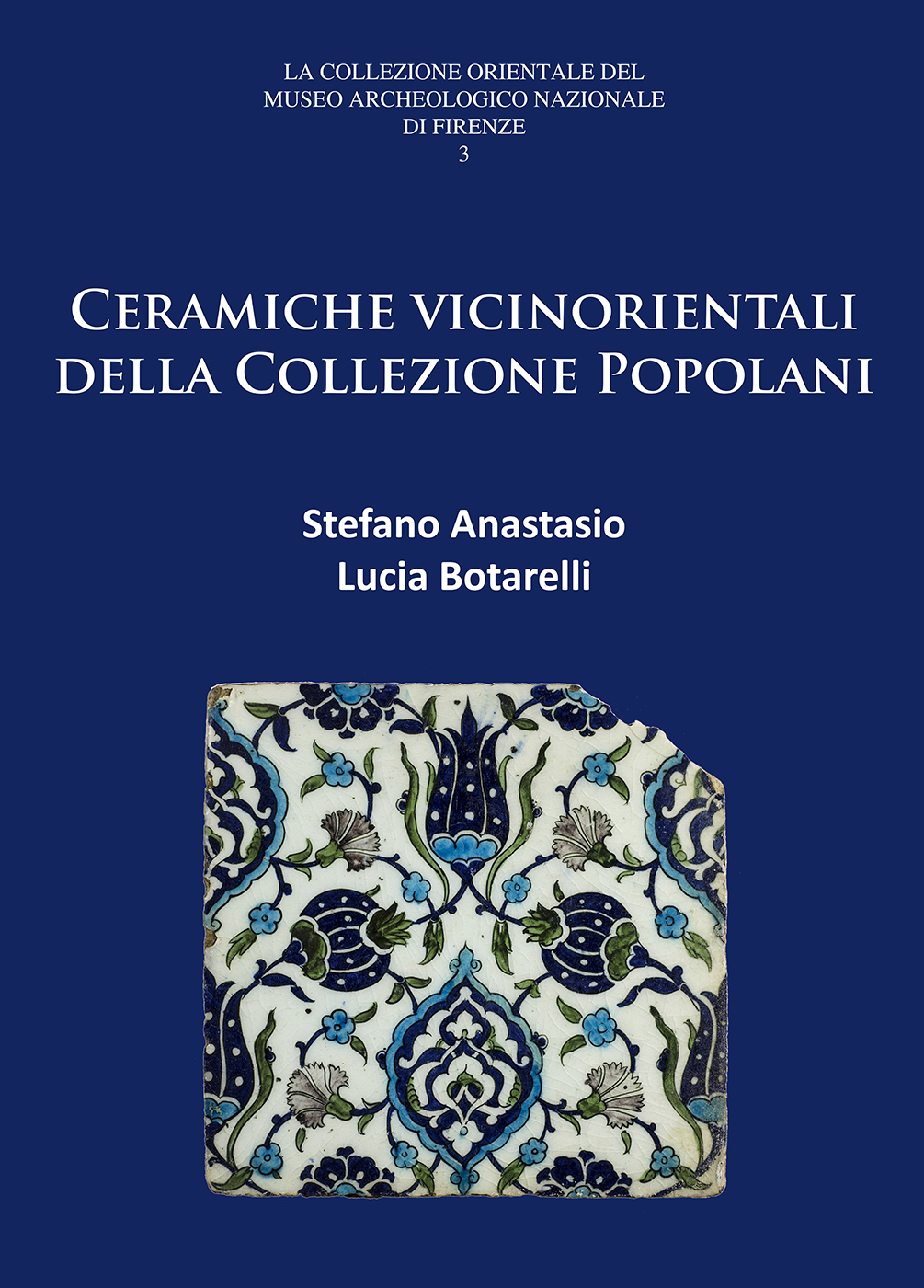
Ceramiche vicinorientali della Collezione Popolani by Stefano Anastasio and Lucia Botarelli. Archaeopress Archaeology, Oxford, 2016.
170x240mm; vi+200 pages; illustrated throughout in colour and black & white. Italian text with English summary.
Paperback: ISBN 9781784914646. £34.00.
eBook: ISBN 9781784914653. From £16.00 (+VAT if appl.).
Archeologia a Firenze: Città e TerritorioAtti del Workshop. Firenze, 12-13 Aprile 2013 edited by Valeria d’Aquino, Guido Guarducci, Silvia Nencetti and Stefano Valentini. Archaeopress Archaeology, Oxford, 2015.
210x297mm; iv+438 pages; illustrated throughout in black & white. Italian text. Abstracts for all papers in Italian & English.
Paperback: ISBN 9781784910587. £58.00
eBook: ISBN 9781784910594. From £16.00 (+VAT if appl.).
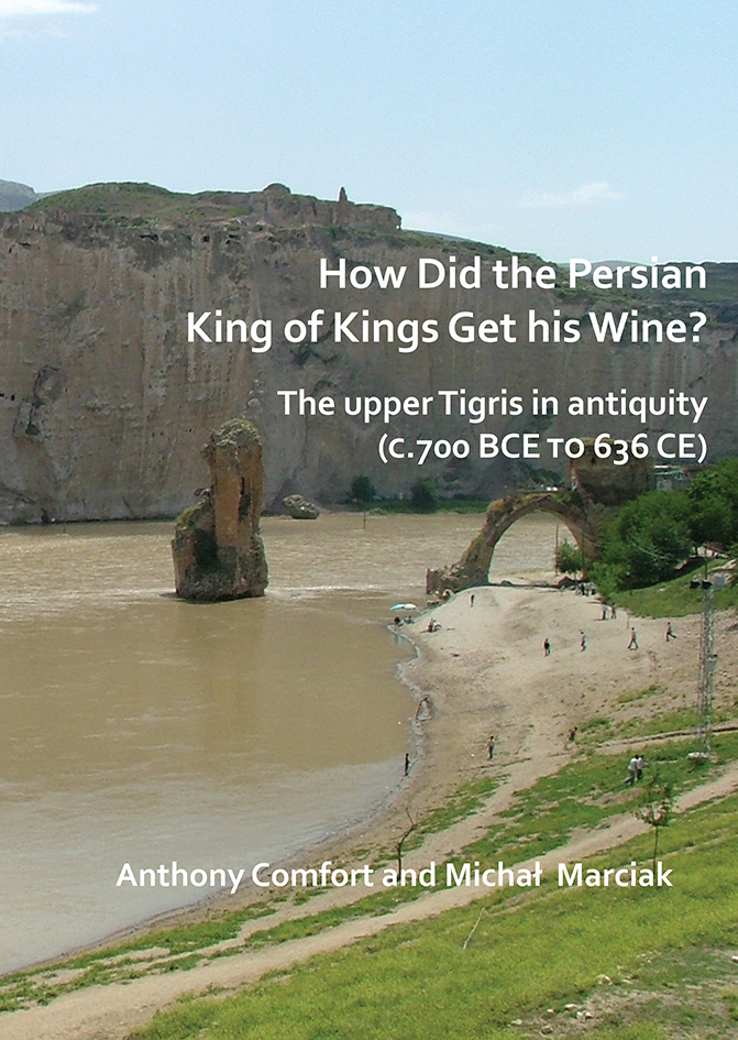
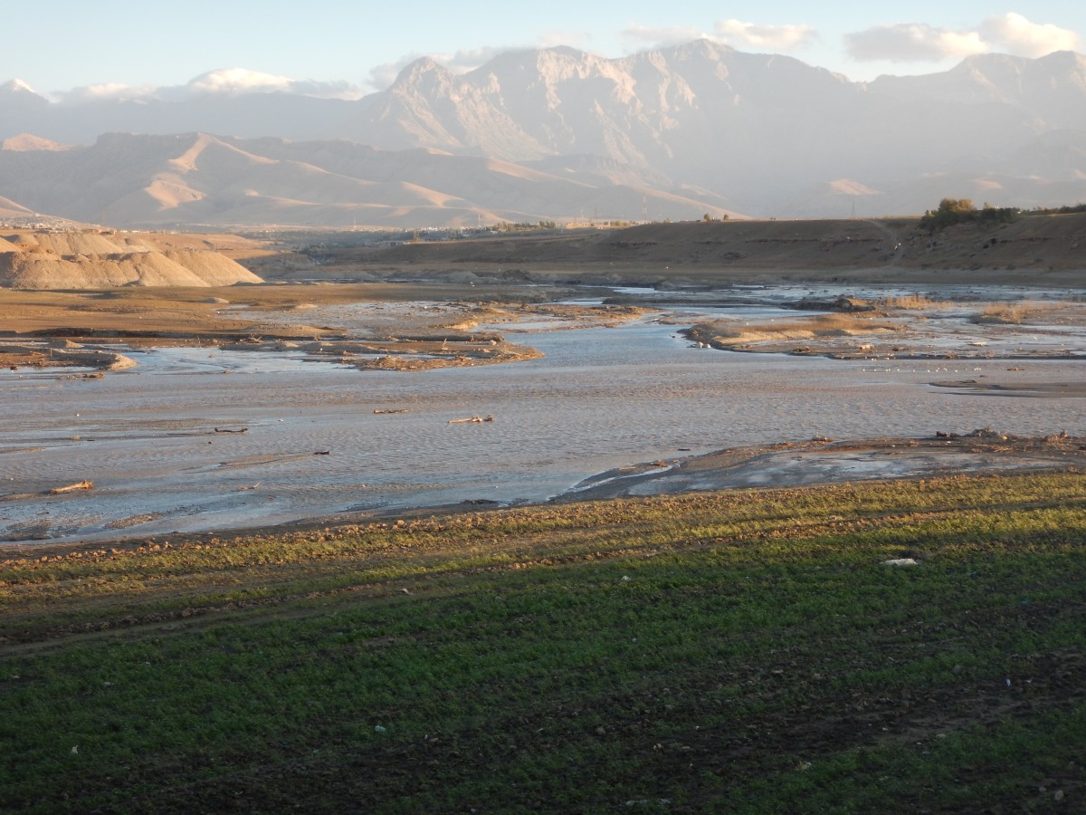
Anthony Comfort and Michal Marciak have written a study of the upper Tigris in antiquity, published in August as How Did the Persian King of Kings Get his Wine? (Archaeopress Archaeology, 2018). This monograph examines an area which has been mostly inaccessible to scholars and looks likely to remain so – despite its great interest and strategic importance during the conflict between Rome and Persia.
The Kasrik gorge from the north (Photo by Michał Marciak 2014)
The publication follows completion of the Ilısu dam, not far from the point at which the modern borders of Turkey, Iraq and Syria meet. When filled the reservoir created by the dam will do serious damage to the environment but also to the cultural heritage of the region; it is obliterating various sites along the river Tigris which are crucial to our understanding of the region’s history and archaeology.
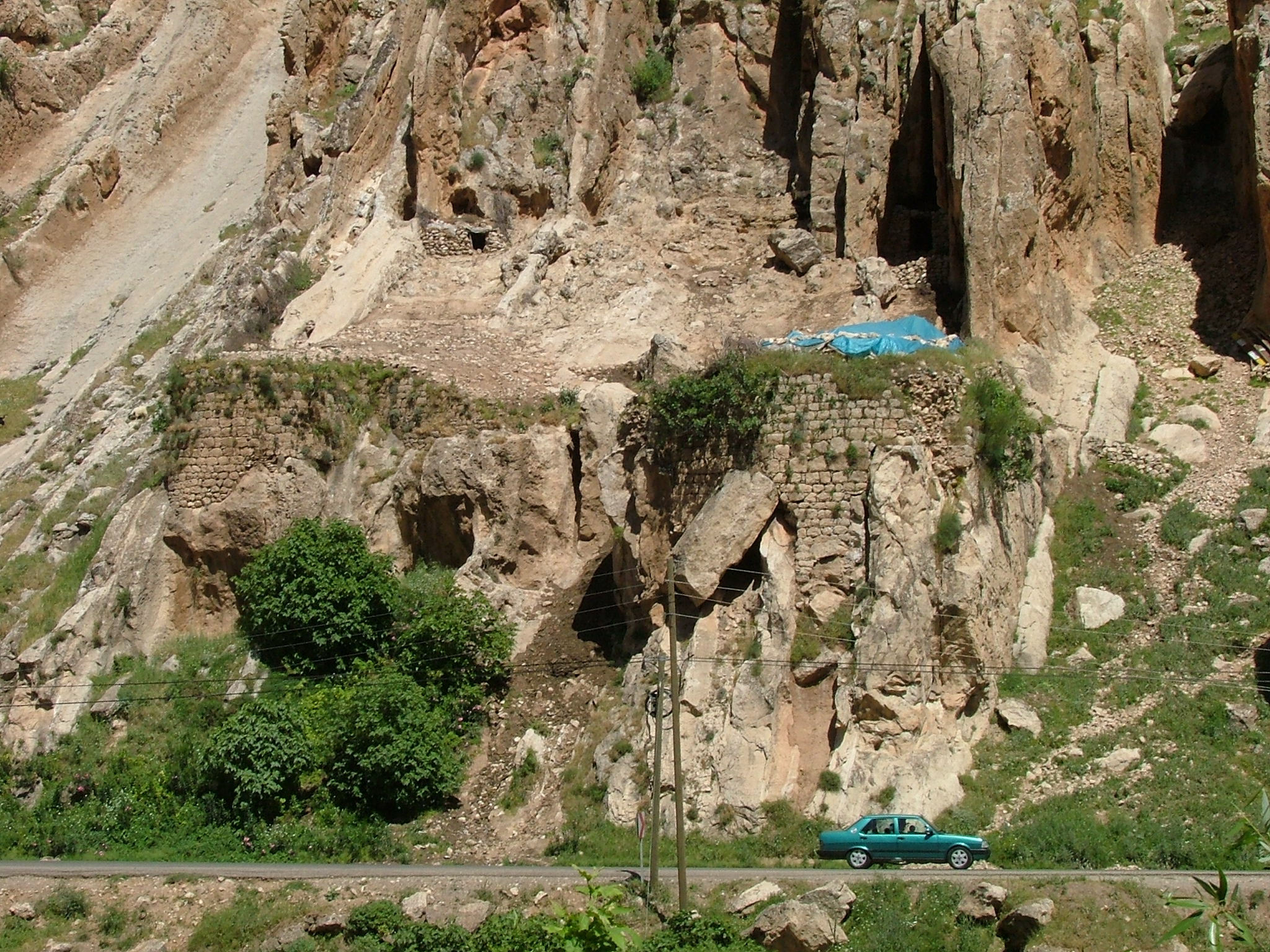
The east bank fort at the Kasrik gorge (Photo by Anthony Comfort 2005)
Apart from the importance of the valley for river and road transport, there are also many rock reliefs which are described in the monograph. It is very sad that the current security situation in South-East Turkey makes many of these reliefs, as well as the sites along the river itself, inaccessible. In Iraqi Kurdistan the situation is better but the Tigris valley there is still difficult to visit for researchers and visitors.
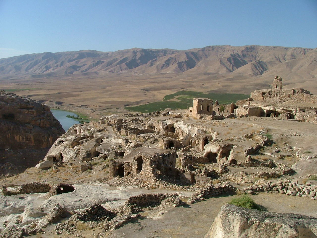
The ‘citadel’ of Hasankeyf (Photo by Anthony Comfort 2005)
At least now the world can have some idea of what is being lost as a result of the Ilısu dam and of what has already disappeared under the waters of the Eski Mosul dam in Iraq. But much of importance remains and needs to be studied further; The monograph provides an introduction to the region’s history and archaeology. The authors intend that it also promote further research in a notoriously difficult part of the world.
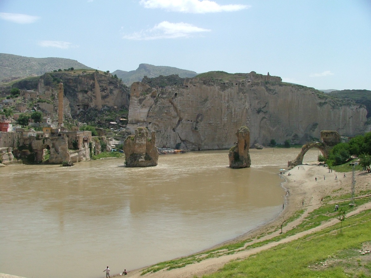
Header image: The old bridge at Hasankeyf in May 2006 (photo by Anthony Comfort)
About the Authors
Anthony Comfort is an independent scholar associated with the Centre for the Study of Greek and Roman Antiquity at Corpus Christi College, Oxford. After a career in the secretariat of the European Parliament, he completed a doctoral dissertation dealing with the roads on the frontier between Rome and Persia at Exeter University under the supervision of Stephen Mitchell. He is a specialist in the use of satellite imagery for archaeology in the Middle East but is now responsible for a project concerning the Roman roads of south-west France, where he lives.
Michał Marciak, PhD (2012), Leiden University, is an Assistant Professor at the Jagiellonian University in Kraków (Poland). He has published extensively on Northern Mesopotamia, including two monographs Izates, Helena, and Monobazos of Adiabene (Harrassowitz, 2014) and Sophene, Gordyene, and Adiabene: Three Regna Minora of Northern Mesopotamia Between East and West (Brill, 2017). He is currently also the Principal Investigator of the Gaugamela Project (in cooperation with the Land of Nineveh Archaeological Project of the University of Udine, Italy) which is dedicated to the identification of the site of the Battle of Gaugamela (331 BCE).
Sincerest thanks to Anthony and Michał for preparing this post for the Archaeopress Blog. Their new book is available now in paperback and PDF eBook editions:


 Why Did Ancient States Collapse? The Dysfunctional State
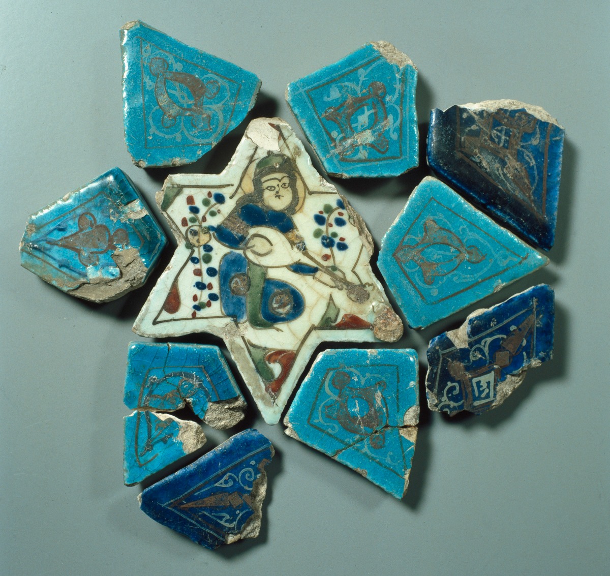


 Sincerest thanks to Hans De Zeeuw for providing this article for the Archaeopress Blog.
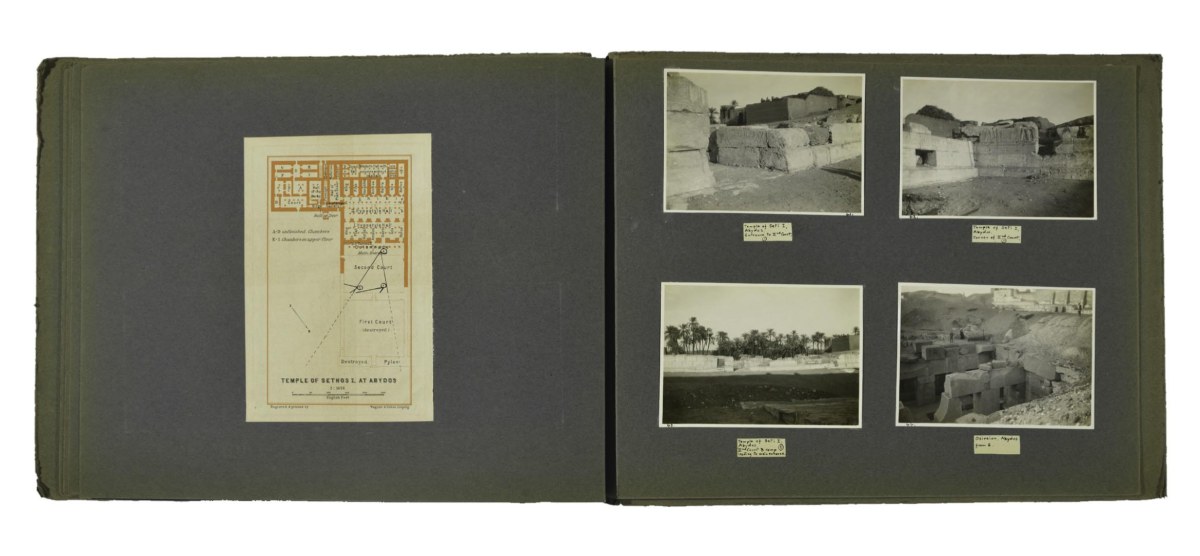

 Ceramiche vicinorientali della Collezione Popolani by Stefano Anastasio and Lucia Botarelli. Archaeopress Archaeology, Oxford, 2016.
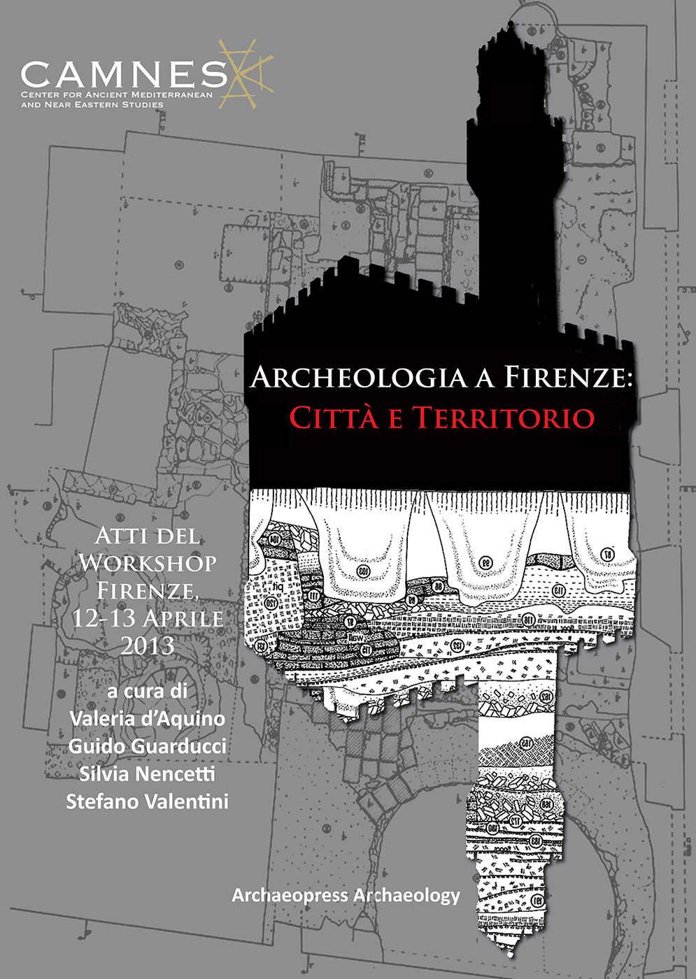 Archeologia a Firenze: Città e Territorio Atti del Workshop. Firenze, 12-13 Aprile 2013 edited by Valeria d’Aquino, Guido Guarducci, Silvia Nencetti and Stefano Valentini. Archaeopress Archaeology, Oxford, 2015.